• Tag Archives snow
  • The Archaeology of Snow

    Winter                                                   Waning Cold Moon

    As the Cold Moon begins to wane, so will the bitterness of our winter,  sliding toward warmer averages, probably more snow, certainly no green for another month plus anyhow.  This winter, like winters of yore, we still have November snow Add Newlayered like archaeological remains below December and those below January.  Even with increased temps we will, most likely, bury these further under a February layer and March until we have five months here, mingled compressed, all vulnerable to the sun that rises higher concentrating its blessing until we discover once again that things still grow here.

    Preached this morning at Groveland.  A repeat of Roots of Liberalism.  I wrote this piece originally for Groveland, but ended up presenting it in Wayzata last Labor Day Sunday.  My October date with Groveland, when I would have given it there, they asked me to do some consulting, help them get on top of their disintegrating community.  Too much work for too few volunteers, an old churchbane.  No easy answers, but they’re still at it.

    When I presented Roots in Wayzata, it went over so well I felt brilliant for an entire afternoon.  Even then, though, I felt near the end I had reached beyond the patience level of the average listener and I felt the same way today.  The reaction today was less effusive and the discussion less rich, but I felt heard again.  Now I can move forward and get to work on Liberalism, part II:  the present.  Due near the end of March.

    Buddy Mark Odegard writes about reading on the beaches of Puerto Vallerta.  He believes we should all emulate the small birds who have the good sense to emigrate during the bleak season to warmer climes.  When I grip the steering wheel with white knuckles while driving on ice, I agree with him.


  • Windy, Snowy

    Winter                               Waning Moon of Long Nights

    We have a light snow here in Andover this morning, winds gusting as high 21 mph yielding windchills in the -5 to -8 ranger.  The ice below the snow continues to give its raggedy feel to driveways and sidewalks and side streets.

    The bulk of this system, both in snow and wind, lies west and south of us, though we will see -20 to -30 windchills by tonight and tomorrow morning.

    Waiting on a call now from Toyota about that flat tire.  Meanwhile, that new novel keeps chugging along.


  • We wait.

    Winter                                      Waxing Moon of Long Nights

    SCATTERED AMOUNTS IN EXCESS OF 20 INCHES PROBABLE. THIS EVENT MAY BECOME COMPARABLE TO THE HALLOWEEN SNOW STORM OF 1991

    Yes, we have the occasional tornado and derecho.   Those are the most damaging and scary weather phenomena that visit us, wrecking their way through country side and towns and cities.  For the most part though, we do not have an equivalent of the hurricane, the fire storm, earthquake or big floods (with the exception of Red River Valley in the far northwestern part of the state).  The only volcanoes we have in the state are long dead.

    We have a mid-continental climate, however, and it can throw some impressive weather our way.  These winter storms* that come at us announce themselves days ahead of time.  The National Weather Service and private meteorologists working for newspapers, TV and radio work hard to keep us informed.

    Minnesotans look forward to these kind of storms since thriving during difficult winter weather defines us as a state and a people.  We all have winter storm stories, whereas only a few have tornado or derecho stories.  Our snow removal system, a sophisticated example of good government, copes with whatever comes, but a really big storm like the one whose northern border is now just south of the metro area, can overwhelm them for a time, after all there is a financial and logistical limit to how many snowplows you can deploy.

    Right now we’re waiting.  I’ve made a lot of leek and potato and chicken noodle soup.  Went to the grocery store yesterday and have plenty of gas for the snowblower.  We have a four wheel drive vehicle with a low 4WD if we need it.

    Let it snow.

    *.A MAJOR STORM SYSTEM PRODUCING HEAVY SNOW…POTENTIALLY NEAR RECORD IN SOME LOCATIONS…AND HAVING CONSIDERABLE IMPACTS ON HOLIDAY GROUND AND AIR TRAVEL…WILL BEGIN ACROSS SOUTHERN AND CENTRAL MINNESOTA AND WEST CENTRAL WISCONSIN BY TONIGHT. SNOWFALL ACCUMULATIONS BY THURSDAY MORNING ARE EXPECTED TO BE BETWEEN TWO AND FIVE INCHES. THE SNOW WILL LAST THROUGH THURSDAY AND CHRISTMAS WITH SIGNIFICANT ACCUMULATIONS FORECAST. THESE ACCUMULATIONS WILL LIKELY BE IN EXCESS OF ONE FOOT…WITH 20 INCHES OR MORE IN SOME LOCATIONS.

    TOTAL ACCUMULATIONS ARE HIGHLY LIKELY TO EXCEED ONE FOOT OVER CENTRAL AND SOUTHERN MINNESOTA AND FAR WESTERN WISCONSIN…WITH SCATTERED AMOUNTS IN EXCESS OF 20 INCHES PROBABLE. THIS EVENT MAY BECOME COMPARABLE TO THE HALLOWEEN SNOW STORM OF 1991. GIVEN THE TIMING OF THIS SYSTEM…HOLIDAY ROAD AND AIR TRAVEL WILL BE SIGNIFICANTLY IMPACTED.

    A WINTER STORM WARNING FOR HEAVY SNOW MEANS SEVERE WINTER WEATHER CONDITIONS ARE EXPECTED OR OCCURRING. SIGNIFICANT AMOUNTS OF SNOW ARE FORECAST THAT WILL MAKE TRAVEL DANGEROUS. ONLY TRAVEL IN AN EMERGENCY. IF YOU MUST TRAVEL…KEEP AN EXTRA FLASHLIGHT… FOOD…AND WATER IN YOUR VEHICLE IN CASE OF AN EMERGENCY.


  • Snow Has Come. Will Stay At Least Through Christmas.

    Samhain                                       Waning Wolf  Moon

    We’ve had steady snow since about 10:30 a.m.  It began to pick up after dark and we now have a couple of inches or more; the leaves have disappeared.  The rocks have become snowy bulges as the wind whips what snow has fallen from place to place.  The warnings have expanded their scope and increased their estimation of snowfall amounts, here in Anoka County we may see 6-8 inches.

    (Armistice Day Blizzard, 1940.  MHS)

    Though these numbers may not fit the technical definition of a blizzard, falling/blowing snow with visibilities under 1/4 mile for at least 3 consecutive hours, sustained winds over 35 mph, but if you happen to get on a road filled with blowing  snow, as you well might, the difference will not mean much to you.  Translation, travel will be dangerous tomorrow.  If you  don’t have to go, stay put.

    Paul Douglas says he does not see above freezing weather between now and December 25th, so he’s predicting a white Christmas.

    The barometer has a steep downward trajectory having fallen .6 of an inch Hg since midnight, very near the mark for bombogenesis which I mentioned in a post early.  This is the equivalent of 20 millibars in just under 24 hours and the definition of bombogenesis is a drop of 24 millibars in 24 hours.  The winds have gusted here already to 24 mph and may go much higher, probably will go up to 35 mph or 40 mph.


  • Let There Be (which) Light?

    Samhain                         Waning Wolf Moon

    The snow continues and the wind now gusts around 12 mph.  Accumulation so far is minimal, but NOAA says the storm will pick up energy tonight and continue on through tomorrow afternoon.  Afterward, the temperature will drop below zero at night and remain in the single digits for highs through Tuesday.  This means winter has come on apace.  Average over these same dates is 27-28 with lows in the teens.  Since October our months have been on a sine curve, wonder if that means January will be balmy?  Unlikely, since it’s typically our coldest month, but with the new weather regimen, who knows?

    We began a while ago to swap out incandescents for CFLs, though there are still places like stairwells and coat closets where the instant on power of the Edison heritage bulbs still make sense.  We’ll switch to LEDSs when they become affordable and equivalent.  It’s still difficult to find CFLs that really match the brightness of incandescents though halogens work well.  These transition periods are difficult, finding the new tech that performs as well as the old one takes time, sometimes several generations of the new one.  We’re not there yet with efficient lighting.  The LED light shown here retails for $129.00.  Yikes!

    Oddly, the post on which I’ve received the most comments was one on the Sunday throat.  Apparently other folks in the US have friends who find the term odd.  Several folks wrote in to say that their family used it.

    Thursday is Jon’s 41st birthday.  Wow.  I met when he was 21.  His life has changed a lot since then.  Most notably sobriety, marriage, two kids, home ownership and a good job.  It’s been fun to see him grow.


  • Let It Snow

    Samhain                                    Waning Wolf Moon

    The snow began around 10:30 a.m., an hour and a half earlier than predicted.   Though the snow is light right now, the wind has stayed pretty steady around 9 mph, driving the snow at a 60 degree angle to the ground.  The wind has increased the windchill factor to 9 degrees, compared to a 17 degree air temperature.

    We have gas, groceries and chew toys for the puppies.  We should be set for a while.  I have my annual physical on December 10th, but the roads should be cleared by then.  If they’re not, I may take the Northstar, but that would leave me stranded in the city until 3 p.m., the first train north.

    When a large snow storm approaches, there is a mild hoarding frenzy that occurs.  Cars line up at gas stations, groceries line extend past their usual points.  People do last minute shopping so they can be done before the roads become difficult.  I did see a guy with two snowmobiles on a trailer hopefully gassing up his truck.

    Once finished with whatever errands and shopping are necessary, if we can, we hunker down and watch it snow.   Later, some of us will strap on snowshoes or cross-country skis and get out to enjoy the changed countryside.

    Right now, Kate and I will take our nap and see what the yard looks like after an hour or so of sleep.


  • Bombogenesis

    Samhain                                       Waning Wolf Moon

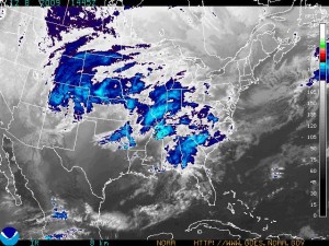
    The anticipation of a snow storm, especially the first one of the season, still generates wonder.  A force of nature moves slowly toward us, we know it will transform our world, change it to some extent beyond recognition, yet it feels benign, unlike the hook echoes, derechos and tornadoes of summer thunderstorms.

    12809goesThe storm continues to lift toward the north.  According to NOAA it will reach us here in the northern suburbs around noon, perhaps a bit later.
    (The GOES shot currently posted on the NOAA website.)

    While reading Paul Douglas on this storm, I learned a new word, bombogenesis–a low that drops its central pressure by 24mb or more in a 24hr period, essentially 1mb per hour for 24 hours.  Why does this matter?  It intensifies the winds in a storm and is more typical, again according to Paul Douglas, of  Nor’easters.  The air rushes in toward the suddenly lower pressure in the middle of the storm.

    I have to put up my Just Needs Snow sign and my snow depth gauge, then head out to Costco.  Oh, boy.


  • Haul the toboggan out of the rafters, wax up those cross-country skis and check the bindings on your snowshoes

    Samhain                                      Waning Wolf Moon

    Find the mittens and the mad bomber hats.  Haul the toboggan out of the rafters, wax up those cross-country skis and check the bindings on your snowshoes.

    Oh, yeah.  You might want gas for the snowblower.  Dig out the snow shovels from that place you put them last March.  Where was that again?

    I don’t know about you but I’m hoping for the big hit.  A good snow fall will amp up the seasonal cheer.

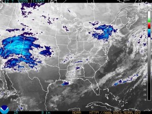
    According to NOAA and Paul Douglas, this is the real deal, heading in with heavier than normal moisture, winds and a track that seems to keep lifting north from the original predictions of a storm that would hit mainly southern Minnesota.winterstormmoving-east

    (NOAA GOES graphic showing the storm as it moves east and north)

    Excerpt below from NOAA Winter Weather Watch:

    MODEL TRENDS OVER THE PAST 12 HOURS HAVE THIS STORM SYSTEM STRONGER AND MAY PRODUCE HIGHER WIND SPEEDS DURING THE HEIGHT OF THE STORM LATE TUESDAY NIGHT…AND INTO WEDNESDAY AFTERNOON.


    THE WINTER STORM WATCH EXTENDS FROM REDWOOD FALLS TO MORA ON EASTWARD…INCLUDING THE TWIN CITIES METROPOLITAN AREA AS WELL AS ALL OF WEST CENTRAL WISCONSIN. SNOW AND STRONG NORTHERLY WINDS ARE POSSIBLE FROM LATE TUESDAY AFTERNOON THROUGH WEDNESDAY WITH SNOW TOTALS REACHING OR EXCEEDING SIX INCHES. A WINTER STORM WATCH MEANS THERE IS A POTENTIAL FOR SIGNIFICANT SNOW…SLEET…OR ICE ACCUMULATIONS THAT MAY IMPACT TRAVEL. CONTINUE TO MONITOR THE LATEST FORECASTS.


  • Winter

    Samhain                                   Waning Wolf Moon

    A light dusting of snow has given snowy caps to the rocks in our boulder wall and covered the potting bench like Wondra shaken out to coat a chicken breast.  This amount of snow emphasizes late fall by highlighting downed leaves, their brown color emphasizing the not-yet-winter feel of this early December Saturday.

    Coming at a lower angle from the sky,  pale sunlight does tell the tale of seasonal change, filtered through a milky haze, giving the morning a starkness seen through leafless trees and their bare branches.  The thermometer, too, suggests winter.  We hit a low this morning of 13 degrees and the temperature stands now at 10:20 a.m. is 20.   This is ten degrees below normal.

    October was cooler than normal; we had our first significant fall then.  November was warmer than normal and we had only a tiny snow fall in a month in which we usually 9-10 inches.  December is now substantially cooler.  This qualifies as strange weather.

    Both NOAA and Paul Douglas predict some snowfall early next week as a strong storm system passes through Iowa, southern Minnesota and into Wisconsin.  We could see amounts in the range of 1-2 inches over 3 days. We get a white Christmas 3 years out of 4.  I hope this is one of them.  A blanket of snow makes the season merrier.

    Gotta go now because I have to prepare a 3-minute speech on fair trade for a fair-trade rally.  I’m representing the Sierra Club and emphasizing the need for environmental regulations to travel with worker’s rights protections–both here and abroad–as goods and services cross international borders.


  • Weather Week Ahead: Colder

    Samhain                                  Full Wolf Moon

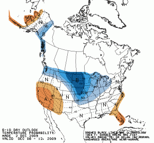
    A light dusting of snow this morning came on the heels of a drop in temperature.  We’re down to 21 right now with a low in the last 24 hours of 20.  According to NOAA and Paul Douglas, we have a bunch of cold air headed our way, air now sitting over the Canadian Prairie provinces.  The 24 hour night over the Arctic combines with the ice and snow covered terrain to produce very cold weather that then squeezes itself out to the south all around the Arctic perimeter.610tempnew

    There is a teeny bit of snow in the forecast, flurries in the 20% probability range.

    The drought conditions have not been updated since November 19th when Anoka County was in the moderately dry range.  The lack of appreciable snow so far can only intensify the drought.

    The area with the B predicts below normal temperatures for the next 6-10 days.

    The bees need me right now and the straw in the back of the truck.  Later on.