Samain Closing Moon
We’ve seen storms over-hyped before, but this one feels pretty solid. Take this assessment from Paul Huttner, author of MPR’s Updraft blog: “It’s tempting to wiggle and obfuscate in winter snows, but I’m paid to make a call. Right now 8″ to 16″ is my forecast snowfall range for the metro, with heaviest totals favoring the north metro.”
And here’s the Winter Storm Warning from NOAA:
“A POTENT STORM SYSTEM WILL BRING SIGNIFICANT SNOWFALL TO MUCH OF
CENTRAL MINNESOTA AND WEST CENTRAL WISCONSIN. OVER 6 INCHES OF
SNOW WILL FALL ALONG AND NORTH OF A LINE FROM CANBY TO GLENCOE TO
HASTINGS IN MN…INCLUDING THE TWIN CITIES METRO…THROUGH EAU
CLAIRE WI. THE HEAVIEST SNOW WILL FALL ALONG A LINE FROM MADISON
TO LITCHFIELD TO ANOKA IN MN THROUGH RICE LAKE WI…WHERE 12 TO 18
INCHES ARE POSSIBLE…ESPECIALLY IN WESTERN WI.” (emphasis mine)
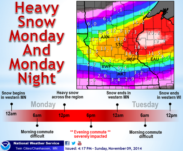
And, finally, the National Weather Service graphic: